Lidar technology is increasingly used in autonomous vehicle navigation systems to create detailed 3D maps of the surrounding environment. By emitting laser pulses and measuring their reflection times, lidar sensors generate highly accurate spatial data. This data allows self-driving cars to detect obstacles, determine distances, and make real-time navigation decisions. In drone navigation, lidar provides precise altitude measurements and terrain mapping, enhancing flight safety and operational efficiency. The high-resolution data from lidar sensors helps drones avoid collisions and maintain stable flight paths in complex environments. These capabilities are vital for applications such as surveillance, agricultural monitoring, and infrastructure inspection.
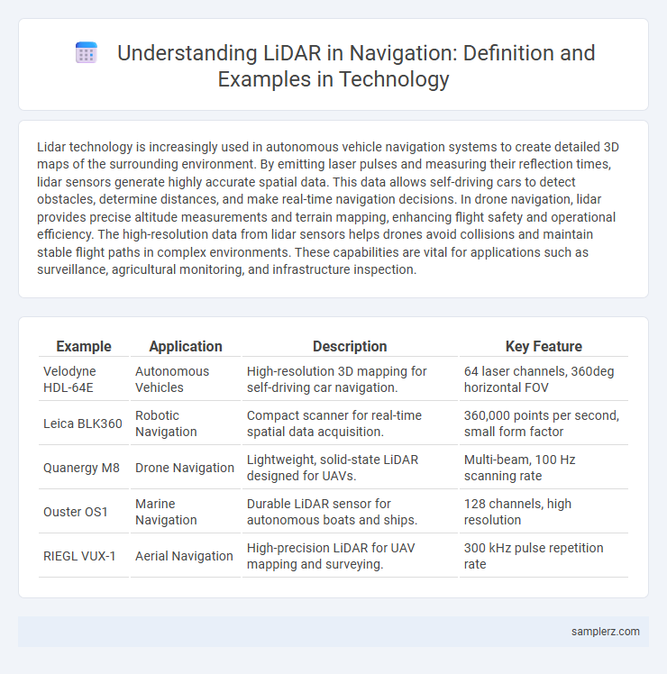
Table of Comparison
| Example | Application | Description | Key Feature |
|---|---|---|---|
| Velodyne HDL-64E | Autonomous Vehicles | High-resolution 3D mapping for self-driving car navigation. | 64 laser channels, 360deg horizontal FOV |
| Leica BLK360 | Robotic Navigation | Compact scanner for real-time spatial data acquisition. | 360,000 points per second, small form factor |
| Quanergy M8 | Drone Navigation | Lightweight, solid-state LiDAR designed for UAVs. | Multi-beam, 100 Hz scanning rate |
| Ouster OS1 | Marine Navigation | Durable LiDAR sensor for autonomous boats and ships. | 128 channels, high resolution |
| RIEGL VUX-1 | Aerial Navigation | High-precision LiDAR for UAV mapping and surveying. | 300 kHz pulse repetition rate |
Overview of LiDAR Technology in Navigation
LiDAR technology enhances navigation by providing high-resolution, three-dimensional mapping through laser pulse measurements, enabling precise obstacle detection and terrain modeling. Autonomous vehicles utilize LiDAR sensors to generate real-time spatial awareness, improving path planning and safety in complex environments. The integration of LiDAR with GPS and inertial navigation systems increases accuracy and reliability in both aerial and maritime navigation applications.
How LiDAR Enhances Autonomous Vehicle Navigation
LiDAR enhances autonomous vehicle navigation by providing precise 3D mapping of the surrounding environment, allowing real-time detection and classification of obstacles, road edges, and traffic signals. High-resolution point clouds generated by LiDAR sensors enable accurate localization even in complex urban settings or low-light conditions. This technology significantly improves safety and decision-making algorithms by delivering reliable distance measurements and spatial awareness critical for self-driving cars.
LiDAR Applications in Maritime Navigation
LiDAR technology enhances maritime navigation by providing precise 3D mapping of coastal and underwater environments, improving vessel safety and route planning. It enables accurate detection of obstacles, seabed topography, and aids in autonomous ship navigation systems. Integration of LiDAR with radar and GPS systems ensures reliable and real-time situational awareness for maritime operations.
Role of LiDAR in Drone-Based Mapping and Navigation
LiDAR technology plays a crucial role in drone-based mapping and navigation by providing high-resolution 3D spatial data that enables precise obstacle detection and terrain modeling. Its ability to generate accurate point clouds allows drones to navigate complex environments autonomously, enhancing the efficiency and safety of aerial surveys. This precise spatial awareness supports applications ranging from agriculture and forestry to urban planning and disaster management.
LiDAR for Railway Navigation and Safety
LiDAR technology is revolutionizing railway navigation and safety by providing high-resolution 3D mapping of tracks and surrounding environments, enabling precise obstacle detection and collision avoidance. Advanced LiDAR sensors continuously monitor track conditions, identifying potential hazards such as debris, objects, or structural defects in real-time. Integration of LiDAR with automated control systems enhances train operation accuracy, boosting overall safety and efficiency in railway networks.
Indoor Navigation Solutions Using LiDAR
LiDAR technology enables precise indoor navigation by creating detailed 3D maps of complex environments, improving accuracy beyond traditional GPS. It supports autonomous robots and smart devices in warehouses, hospitals, and retail spaces by detecting obstacles and dynamically updating routes in real-time. Integration of LiDAR sensors with AI algorithms enhances spatial awareness and optimizes pathfinding for efficient indoor navigation solutions.
LiDAR in Robotic Navigation Systems
LiDAR technology plays a critical role in robotic navigation systems by providing precise 3D mapping and obstacle detection. Robots equipped with LiDAR sensors can generate detailed environmental models, enabling real-time path planning and autonomous movement. This enhances the accuracy and safety of navigation in complex and dynamic environments such as warehouses and autonomous vehicles.
Advancements in LiDAR for Urban Traffic Management
Recent advancements in LiDAR technology have significantly enhanced urban traffic management by providing high-resolution, real-time 3D mapping and accurate object detection in complex city environments. Integration of LiDAR sensors with AI algorithms enables precise vehicle positioning and traffic flow analysis, reducing congestion and improving safety. Cities implementing next-generation LiDAR systems report improved traffic signal optimization and increased efficiency in autonomous vehicle navigation.
Integrating LiDAR with GPS for Precision Navigation
Integrating LiDAR with GPS enhances precision navigation by providing high-resolution 3D mapping and accurate positioning in environments where GPS signals alone are insufficient, such as urban canyons and dense forests. This combination improves autonomous vehicle guidance by enabling real-time obstacle detection and path optimization, leveraging LiDAR's detailed spatial data alongside GPS coordinates. Advanced algorithms fuse LiDAR point clouds with satellite navigation data, resulting in robust, reliable navigation systems critical for drones, self-driving cars, and robotic applications.
Future Trends of LiDAR in Navigation Technologies
LiDAR technology in navigation is evolving with advancements such as higher resolution sensors and real-time data processing capabilities. Future trends include the integration of AI algorithms to enhance object detection and mapping accuracy in autonomous vehicles and drones. Innovations in compact, energy-efficient LiDAR systems are expected to drive widespread adoption across urban mobility and robotic navigation platforms.
example of lidar in navigation Infographic