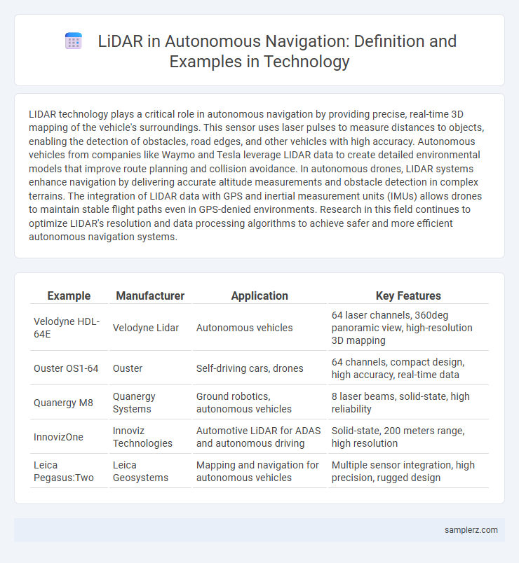
LIDAR technology plays a critical role in autonomous navigation by providing precise, real-time 3D mapping of the vehicle's surroundings. This sensor uses laser pulses to measure distances to objects, enabling the detection of obstacles, road edges, and other vehicles with high accuracy. Autonomous vehicles from companies like Waymo and Tesla leverage LIDAR data to create detailed environmental models that improve route planning and collision avoidance. In autonomous drones, LIDAR systems enhance navigation by delivering accurate altitude measurements and obstacle detection in complex terrains. The integration of LIDAR data with GPS and inertial measurement units (IMUs) allows drones to maintain stable flight paths even in GPS-denied environments. Research in this field continues to optimize LIDAR's resolution and data processing algorithms to achieve safer and more efficient autonomous navigation systems.
Table of Comparison
| Example | Manufacturer | Application | Key Features |
|---|---|---|---|
| Velodyne HDL-64E | Velodyne Lidar | Autonomous vehicles | 64 laser channels, 360deg panoramic view, high-resolution 3D mapping |
| Ouster OS1-64 | Ouster | Self-driving cars, drones | 64 channels, compact design, high accuracy, real-time data |
| Quanergy M8 | Quanergy Systems | Ground robotics, autonomous vehicles | 8 laser beams, solid-state, high reliability |
| InnovizOne | Innoviz Technologies | Automotive LiDAR for ADAS and autonomous driving | Solid-state, 200 meters range, high resolution |
| Leica Pegasus:Two | Leica Geosystems | Mapping and navigation for autonomous vehicles | Multiple sensor integration, high precision, rugged design |
Introduction to LIDAR in Autonomous Navigation
LIDAR technology uses laser pulses to create precise 3D maps of the environment, enabling autonomous vehicles to detect obstacles and navigate safely. By emitting rapid laser beams and measuring their reflections, LIDAR systems generate high-resolution spatial data critical for real-time decision-making. This sensor technology enhances situational awareness and supports advanced driver-assistance systems (ADAS) by providing detailed environmental perception in varying light and weather conditions.
Role of LIDAR Sensors in Self-Driving Cars
LIDAR sensors play a crucial role in self-driving cars by providing precise 3D mapping of the environment, enabling accurate detection of obstacles, road edges, and pedestrians. These sensors emit laser pulses that measure distances to surrounding objects, facilitating real-time navigation and collision avoidance. Advanced LIDAR technology enhances vehicle localization and perception, ensuring safer and more reliable autonomous driving systems.
LIDAR-Based Obstacle Detection and Avoidance
LIDAR-based obstacle detection and avoidance systems enable autonomous vehicles to create precise, real-time 3D maps of their surroundings by emitting laser pulses and measuring their reflections. This technology accurately identifies and classifies obstacles, including pedestrians, other vehicles, and road barriers, enhancing navigation safety and efficiency. Examples include Waymo's autonomous cars and Tesla's advanced driver-assistance systems, which rely on LIDAR sensors to improve decision-making in complex driving environments.
Mapping and Localization Using LIDAR
LIDAR technology enables precise 3D mapping by emitting laser pulses to measure distances and create detailed environmental models for autonomous navigation systems. This high-resolution spatial data allows vehicles to localize themselves accurately within complex environments, enhancing real-time decision-making and obstacle avoidance. Advanced algorithms process LIDAR point clouds to generate and update dynamic maps essential for reliable route planning and safe navigation.
Integration of LIDAR with Other Sensor Technologies
LIDAR technology enhances autonomous navigation by integrating seamlessly with radar and camera systems, providing comprehensive environmental perception. This sensor fusion improves object detection accuracy and real-time mapping for autonomous vehicles. Combining LIDAR's high-resolution distance measurements with radar's velocity data and cameras' visual context enables robust and reliable navigation in complex environments.
LIDAR in Drone Navigation Systems
LIDAR technology enables drones to generate real-time 3D maps of their surroundings, enhancing obstacle detection and collision avoidance in autonomous navigation. By emitting laser pulses and measuring the reflected signals, LIDAR systems provide precise distance and depth information critical for stable flight control and path planning. Integration of LIDAR sensors in drone navigation systems improves accuracy in complex environments, supporting applications such as aerial surveying, agriculture monitoring, and search-and-rescue operations.
LIDAR Applications in Autonomous Delivery Robots
LIDAR technology enables autonomous delivery robots to create real-time 3D maps of their surroundings, ensuring accurate obstacle detection and navigation in complex urban environments. These robots utilize precise distance measurements from LIDAR sensors to avoid collisions and optimize delivery routes efficiently. Integration of LIDAR with AI algorithms enhances situational awareness, improving safety and reliability in last-mile logistics operations.
Real-Time Environment Perception with LIDAR
LIDAR technology enables autonomous vehicles to perform real-time environment perception by generating precise 3D maps of surrounding objects and terrain. Its high-resolution point cloud data allows for accurate detection of obstacles, road edges, and dynamic elements in complex urban settings. Integrating LIDAR with advanced algorithms ensures continuous situational awareness essential for safe and efficient autonomous navigation.
Case Studies: LIDAR in Commercial Autonomous Vehicles
Case studies demonstrate LIDAR's critical role in commercial autonomous vehicles like Waymo's self-driving taxis and Amazon's delivery robots, enabling precise 3D mapping and real-time obstacle detection. In complex urban environments, LIDAR sensors provide high-resolution spatial data that enhances navigation accuracy and safety. These implementations highlight LIDAR's effectiveness in improving operational efficiency and reducing collision risks in commercial autonomous transport.
Future Trends of LIDAR in Autonomous Navigation
Emerging LIDAR technologies in autonomous navigation emphasize solid-state sensors that offer enhanced durability and reduced costs, accelerating widespread adoption. Integration with AI-driven perception systems improves real-time environment mapping and obstacle detection precision, crucial for higher levels of vehicle autonomy. Advancements in miniaturization and multi-sensor fusion will enable seamless navigation in complex urban settings, driving innovations in autonomous delivery and mobility services.

example of LIDAR in autonomous navigation Infographic
 samplerz.com