Synthetic aperture radar (SAR) is a technology used to create high-resolution images of landscapes and objects. It works by moving a radar antenna over a target area, collecting data from multiple angles to simulate a larger antenna size. The data processed from these multiple observations allows the system to produce detailed images even through clouds or darkness. A key entity in SAR technology is the radar platform, which can be mounted on satellites, aircraft, or drones. By measuring the time delay and phase of the returning radar signals, the system generates precise spatial information. Synthetic aperture radar is widely used in earth observation, military surveillance, and environmental monitoring for its ability to provide accurate and detailed data regardless of weather conditions.
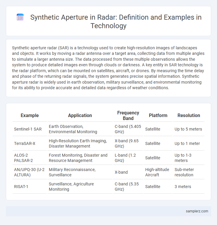
Table of Comparison
| Example | Application | Frequency Band | Platform | Resolution |
|---|---|---|---|---|
| Sentinel-1 SAR | Earth Observation, Environmental Monitoring | C-band (5.405 GHz) | Satellite | Up to 5 meters |
| TerraSAR-X | High-Resolution Earth Imaging, Disaster Management | X-band (9.65 GHz) | Satellite | Up to 1 meter |
| ALOS-2 PALSAR-2 | Forest Monitoring, Disaster and Resource Management | L-band (1.2 GHz) | Satellite | Up to 1-3 meters |
| AN/UPQ-30 (U-2 ALTURA) | Military Reconnaissance, Surveillance | X-band | High-altitude Aircraft | Sub-meter resolution |
| RISAT-1 | Surveillance, Agriculture Monitoring | C-band (5.35 GHz) | Satellite | 3 meters |
Understanding Synthetic Aperture in Radar Technology
Synthetic aperture radar (SAR) technology uses the motion of a radar antenna over a target region to create high-resolution images, surpassing conventional radar limitations. By synthesizing a large antenna aperture from multiple radar returns, SAR achieves detailed imaging crucial for applications in earth observation, military reconnaissance, and environmental monitoring. Understanding the principles of SAR signals and processing algorithms is essential for optimizing image clarity and enhancing target detection capabilities.
Principles Behind Synthetic Aperture Radar (SAR)
Synthetic Aperture Radar (SAR) operates by moving a radar antenna over a target region to simulate a much larger antenna aperture, enhancing spatial resolution beyond physical antenna limits. It emits microwave pulses and records the reflected signals over time, using the platform's motion to create high-resolution, two-dimensional images through signal processing techniques like range and azimuth compression. The coherent combination of received echoes along the flight path synthesizes a large aperture, enabling detailed imaging in various environmental conditions, including through clouds and darkness.
Key Components of Synthetic Aperture Radar Systems
Synthetic Aperture Radar (SAR) systems rely on key components such as the radar antenna, motion platform, signal processor, and data storage unit to generate high-resolution images. The radar antenna transmits microwave pulses and receives echoes, while the motion platform ensures consistent movement to synthesize a large aperture. Advanced signal processors analyze returned signals to create detailed radar imagery used in terrain mapping, surveillance, and environmental monitoring.
Examples of Synthetic Aperture Implementation in Satellites
Synthetic aperture radar (SAR) is utilized in satellites such as ESA's Sentinel-1 and NASA's NISAR mission to generate high-resolution Earth imagery regardless of weather conditions or daylight. These satellites employ synthetic aperture techniques by moving the radar antenna over a target area to simulate a much larger antenna, enhancing spatial resolution. The resulting data aids in applications like environmental monitoring, disaster management, and terrain mapping.
Synthetic Aperture Techniques in Airborne Radar Platforms
Synthetic aperture techniques in airborne radar platforms utilize the motion of the aircraft to simulate a large antenna array, significantly enhancing spatial resolution. By coherently processing the radar echoes over time, these systems generate high-resolution two-dimensional images despite using relatively small physical antennas. Airborne synthetic aperture radar (SAR) applications include terrain mapping, surveillance, and reconnaissance, benefiting from improved target detection and identification capabilities.
Real-World Applications of Synthetic Aperture Radar
Synthetic Aperture Radar (SAR) is widely used in Earth observation for detailed topographical mapping and environmental monitoring, providing high-resolution images regardless of weather conditions or daylight. Its application in disaster management enables precise damage assessment during floods, earthquakes, and landslides, enhancing emergency response efforts. SAR is also integral to maritime surveillance, tracking ship movements and detecting oil spills to support national security and environmental protection.
Comparative Analysis: Synthetic Aperture vs. Conventional Radar
Synthetic aperture radar (SAR) significantly outperforms conventional radar in spatial resolution by synthesizing a larger antenna aperture through the motion of the radar platform, enabling detailed imaging regardless of weather or lighting conditions. Conventional radar systems rely on physically large antennas to achieve resolution, which limits their deployment flexibility and increases costs. SAR's ability to generate high-resolution two-dimensional images with compact hardware has made it indispensable for applications such as earth observation, surveillance, and reconnaissance.
Advancements in Digital Signal Processing for SAR
Advancements in digital signal processing for synthetic aperture radar (SAR) have significantly enhanced image resolution and target detection capabilities by utilizing algorithms such as the Range-Doppler and Chirp Scaling methods. High-performance processors enable real-time data acquisition and sophisticated phase error correction, improving the clarity and accuracy of radar imagery in diverse environmental conditions. Machine learning integration further optimizes clutter suppression and feature extraction, facilitating more reliable and efficient applications in reconnaissance and environmental monitoring.
Synthetic Aperture Radar in Environmental Monitoring
Synthetic Aperture Radar (SAR) is extensively used in environmental monitoring for its ability to capture high-resolution images regardless of weather conditions or daylight. This technology enables detailed observation of forest cover changes, wetland mapping, and flood extent analysis, providing critical data for disaster management and climate studies. SAR's capability to penetrate vegetation and soil surfaces allows for accurate monitoring of land subsidence and glacier movements over time.
Future Trends in Synthetic Aperture Radar Technology
Future trends in synthetic aperture radar (SAR) technology emphasize enhanced resolution through advanced signal processing algorithms and real-time data analytics, enabling more precise imaging for applications like autonomous navigation and environmental monitoring. Integration of AI and machine learning techniques improves target detection and classification, driving innovations in defense and disaster response systems. Miniaturization and satellite constellation deployments are expanding global coverage and accessibility, paving the way for uninterrupted, high-frequency Earth observation.
example of synthetic aperture in radar Infographic