LiDAR technology plays a crucial role in mapping by providing high-resolution spatial data through laser scanning. It measures distances by illuminating targets with laser light and analyzing the reflected pulses, generating accurate 3D models of the terrain. This technology is widely used for topographic mapping, urban planning, and environmental monitoring due to its precision and efficiency. In forestry management, LiDAR data helps create detailed elevation maps of forest canopies and ground surfaces, enabling better assessment of biomass and tree health. Autonomous vehicles rely on LiDAR sensors to map their surroundings in real-time, ensuring safe navigation through complex environments. These applications highlight LiDAR's importance in modern mapping tasks where accuracy and rapid data acquisition are essential.
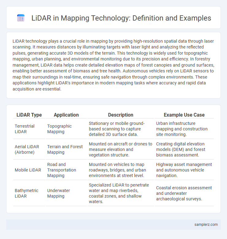
Table of Comparison
| LiDAR Type | Application | Description | Example Use Case |
|---|---|---|---|
| Terrestrial LiDAR | Topographic Mapping | Stationary or mobile ground-based scanning to capture detailed 3D surface data. | Urban infrastructure mapping and construction site monitoring. |
| Aerial LiDAR (Airborne) | Terrain and Forest Mapping | Mounted on aircraft or drones to measure elevation and vegetation structure. | Creating digital elevation models (DEM) and forest biomass assessment. |
| Mobile LiDAR | Road and Transportation Mapping | Mounted on vehicles to map roadways, bridges, and urban environments at street level. | Highway asset management and autonomous vehicle navigation. |
| Bathymetric LiDAR | Underwater Mapping | Specialized LiDAR to penetrate water and map riverbeds, coastal zones, and shallow waters. | Coastal erosion assessment and underwater archaeological surveys. |
Introduction to LiDAR Technology in Mapping
LiDAR technology uses laser pulses to generate precise, high-resolution 3D maps by measuring the time it takes for light to reflect off surfaces and return to the sensor. In mapping applications, LiDAR enables detailed topographic and terrain analysis, greatly enhancing accuracy in both urban planning and environmental monitoring. This technology's ability to rapidly capture extensive spatial data outperforms traditional surveying methods, making it indispensable for modern geospatial mapping projects.
Key Principles of LiDAR Mapping
LiDAR mapping operates by emitting laser pulses that measure distances to surfaces, creating precise three-dimensional representations of environments. Key principles include time-of-flight calculations to determine object distance, high pulse repetition rates for dense data acquisition, and GPS integration for accurate georeferencing. These elements combine to produce detailed topographic maps used in applications such as urban planning, forestry management, and autonomous vehicle navigation.
LiDAR Applications in Topographic Surveys
LiDAR technology significantly enhances topographic surveys by providing precise elevation data and high-resolution terrain models. Its ability to penetrate vegetation makes it invaluable for mapping forested areas and complex landscapes with dense canopy cover. This precision supports civil engineering, urban planning, and environmental monitoring through detailed digital elevation models (DEMs) and contour maps.
LiDAR for Urban Planning and Infrastructure
LiDAR technology enables precise 3D mapping of urban environments, facilitating detailed analysis for urban planning and infrastructure development. It provides accurate elevation data and structural details essential for designing road networks, utility management, and land use planning. Municipalities leverage LiDAR to optimize zoning, monitor construction progress, and enhance disaster resilience through topographical modeling.
Forest and Vegetation Mapping with LiDAR
LiDAR technology enables precise forest and vegetation mapping by generating high-resolution 3D models of canopy structure and terrain elevation. It captures detailed data on tree height, density, and biomass, facilitating accurate assessments of forest health and carbon stock estimation. Integrating LiDAR with GIS enhances habitat monitoring and sustainable forest management practices.
LiDAR’s Role in Coastal and Floodplain Mapping
LiDAR technology enables precise elevation data collection crucial for coastal and floodplain mapping, enhancing the accuracy of topographic models and flood risk assessments. High-resolution LiDAR point clouds capture detailed terrain features, supporting the creation of dynamic inundation maps and shoreline change detection. Integration of LiDAR data with GIS platforms facilitates improved management of coastal erosion, habitat preservation, and flood mitigation planning.
Archaeological Discoveries Using LiDAR
LiDAR technology has revolutionized archaeological mapping by providing high-resolution, three-dimensional images of landscapes hidden beneath dense vegetation. The discovery of ancient Mayan cities in Guatemala exemplifies LiDAR's ability to reveal previously unknown structures and settlement layouts without excavation. This non-invasive method accelerates research and preserves site integrity, transforming archaeological exploration.
Integration of LiDAR with GIS Systems
LiDAR technology enhances mapping precision by creating high-resolution 3D models integrated with Geographic Information Systems (GIS). Combining LiDAR point cloud data with GIS layers allows for advanced spatial analysis, improved land use planning, and infrastructure management. This integration supports real-time decision-making in urban development, environmental monitoring, and disaster response.
Challenges and Limitations of LiDAR in Mapping
LiDAR technology in mapping faces challenges such as signal interference from dense vegetation and complex urban environments, which can compromise data accuracy. High costs and extensive data processing requirements also limit its widespread adoption. Furthermore, LiDAR systems often struggle with reflective surfaces and varying weather conditions, reducing reliability in certain mapping scenarios.
Future Trends in LiDAR Mapping Technology
Emerging LiDAR technologies such as solid-state sensors and quantum LiDAR are set to revolutionize mapping accuracy and resolution, enabling unprecedented detail in 3D terrain modeling. Integration of AI-driven data analysis will accelerate real-time processing and enhance predictive capabilities in urban planning and autonomous navigation. Future LiDAR mapping will leverage advancements in miniaturization and cost-efficiency, expanding applications across environmental monitoring, disaster management, and smart city development.
example of LiDAR in mapping Infographic