A plat in a subdivision is a detailed map that outlines the division of a large parcel of land into smaller lots for development. It includes precise measurements of boundaries, streets, easements, and public areas, ensuring legal clarity for property ownership. Developers and local authorities use plats to organize and regulate land use within residential communities. Plats are essential in real estate transactions as they provide crucial data on lot size, zoning requirements, and access points. Surveyors create plats using geographic information system (GIS) technology to ensure accuracy and compliance with municipal codes. This documentation supports both buyers and sellers in understanding property layouts and subdivision plans.
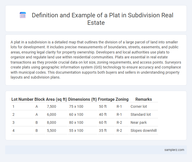
Table of Comparison
| Lot Number | Block | Area (sq ft) | Dimensions (ft) | Frontage | Zoning | Remarks |
|---|---|---|---|---|---|---|
| 1 | A | 7,500 | 75 x 100 | 50 ft | R-1 | Corner lot |
| 2 | A | 6,000 | 60 x 100 | 40 ft | R-1 | Standard lot |
| 3 | B | 8,000 | 80 x 100 | 60 ft | R-2 | Near park |
| 4 | B | 5,500 | 55 x 100 | 35 ft | R-2 | Slopes downhill |
What Is a Plat in Real Estate Subdivisions?
A plat in real estate subdivisions is a detailed map that outlines the divisions of a parcel of land into lots, streets, and public areas, serving as a legal document for property boundaries. This survey includes precise measurements, easements, and street layouts, ensuring clear ownership and development guidelines. Plats are essential for obtaining permits, recording with local governments, and guiding construction within the subdivision.
Key Components Found on a Subdivision Plat
A subdivision plat typically includes key components such as lot lines, street layouts, easements, and utility locations, all crucial for defining property boundaries and access routes. It also features block numbers, dimensions of each lot, and designated public areas like parks or drainage systems to ensure proper land use and community planning. Accurate survey data and legal descriptions on the plat facilitate title searches and future development approvals within the subdivision.
Types of Plats Used in Residential Developments
Residential developments commonly utilize several types of plats, including subdivision plats, which detail the division of a larger tract into individual lots with streets and easements clearly marked. Boundary plats define precise property lines to prevent disputes and support legal descriptions essential for property sales and permits. Site development plats illustrate the proposed layout of buildings, infrastructure, and landscaping to ensure compliance with zoning regulations and streamline the approval process.
Example of a Plat Map: Typical Features and Symbols
A plat map in a subdivision typically displays detailed parcel boundaries, lot dimensions, street layouts, easements, and utility placements, providing essential data for developers and buyers. Key symbols include solid lines for property lines, dashed lines for easements, and shaded areas for common spaces like parks or retention ponds. These standardized features ensure clear communication of spatial arrangements and legal descriptions critical for land use planning and property transactions.
Understanding Lot Lines and Boundaries on a Plat
A plat in a subdivision clearly illustrates lot lines and boundaries, defining property dimensions with precise measurements and angles. Each lot is marked with bearings and distances, indicating exact perimeters that distinguish one property from another. Accurate interpretation of these lines is essential for property ownership, development, and resolving boundary disputes.
Legal Importance of Plats in Property Subdivision
A plat is a detailed map that legally defines property boundaries, easements, and streets within a subdivision, serving as an official record for local government and property owners. Its legal importance lies in providing clear documentation for ownership rights, property descriptions, and development restrictions, which helps prevent disputes and ensures compliance with zoning laws. Accurate plats are essential for property transactions, securing permits, and facilitating infrastructure development in real estate projects.
How to Read and Interpret a Subdivision Plat
A subdivision plat is a detailed map showing the division of a parcel of land into lots, streets, and easements, used in real estate development and land sales. To read a subdivision plat, focus on identifying parcel boundaries, lot dimensions, right-of-ways, and utility easements clearly marked with measurements and symbols. Understanding the legend, scale, and north arrow helps interpret property lines, street layouts, and access points critical for legal descriptions and development planning.
Role of Plats in Zoning and Land Use Planning
Plats serve as detailed maps illustrating the division of land within a subdivision, delineating property boundaries, streets, easements, and parcels crucial for zoning compliance and land use planning. They provide local governments and developers with precise information necessary for enforcing zoning regulations, allocating public spaces, and planning infrastructure development. Accurate plats ensure orderly growth by guiding permissible land uses, supporting municipal planning objectives, and facilitating property transactions within the subdivision.
Subdivision Plat Approval Process Explained
Subdivision plat approval involves submitting detailed maps indicating parcel boundaries, road layouts, and utility easements to local government authorities for verification. The approval process ensures compliance with zoning laws, land use regulations, and infrastructure requirements before development proceeds. Timely plat approval is critical for securing permits, coordinating construction phases, and facilitating property sales within the subdivision.
Frequently Asked Questions About Subdivision Plats
Subdivision plats detail property boundaries, easements, and lot dimensions essential for legal land division and development. Common questions address how plats affect property ownership, zoning compliance, and access rights within a subdivision. Review of plat maps is crucial for buyers, developers, and local authorities to ensure accurate land use and infrastructure planning.
example of plat in subdivision Infographic